
GIS MAPPING
GEO CHEMISTRY
PROJECT MANAGEMENT

ABOUT
Fully equipped, flexible and adaptable to location and client requirements, Allan Ronk provides a strong, varied geological mapping and GIS integrated service. This includes regional perspectives to local mine site scale exploration, often in remote and/or difficult access environments.
Exploration utilises available data; historical, current, geochemical, drilling, imagery and geophysics to find and investigate mapping and geochemical anomalies.
GIS software is integrated with ioGAS (software for geochemical data validation and investigation) coupled to aerial/satellite, aeromagnetic, radiometric and various spectral imagery and digital elevation modelling (Pix4D Pro, Global Mapper) as required. Photographic software produces further enhancements for visualisation purposes where suitable.
Allan’s mapping and exploration experience covers precious, base and other metals/minerals from both desert to tropical environments. This has included planning, management and supervision of drill programmes with subsequent compilation and interpretation into 3D environments including Mapinfo Pro and Discover 3D.
Previous roles have included project management in close liaison with their teams.
Other experience involves agricultural project design, dam site modelling, large scale irrigation setup and horticultural optimisation.
Allan can drive heavy vehicles (HR drivers’ licence), operates his own aircraft and has many years’ experience with 4WD and 6WD off road machines and now uses a field prepared Gator XUV (crossover utility vehicle).
A & S Ronk was formed in the late 1980’s and in 2010 became Karri Hill GIS Pty Ltd.
Susan Ronk has managed offices, logistics and field support in Australia and Africa. Her professional experience includes sampling and sample control from all types of drilling (including core management), geochemical sampling, and is familiar with the collection of GIS field data. Susan has much experience with 4WD and 6WD off road equipment, often in remote terrains.

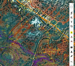

Using geo-location and annotation programs, field data is collected via portable devices.
This method will accommodate large variations in mapping scale allowing suitable detail to be added locally into more regional maps.

This example of a geological map is part of a larger scale basin mapping programme and has incorporated both kilometre and drill scale data and marker horizons.
Once this stage of the mapping is reached, the geological information can be used in a variety of applications, including mobile devices or similar as geo referenced maps if desired.
This data was applied into 3D and drilling applications in the illustration below.

Another relatively new tool is the ability to use large amounts georeferenced imagery integrated into GIS (Mapinfo) for direct referencing. With this method thousands of images can be handled and utilized as location in itself provides immediate filtering during actual use. Additional notes can be added to the interrogatable photographic data base as required.
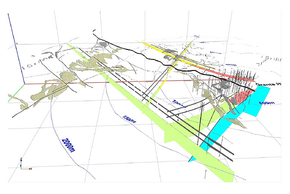
A snap shot of 3D sections constructed from mapping and drill information. This work illustrates advantages of bringing geological information from well beyond the local tenement boundaries and adding it to drill scale exploration and surface sampling.
In this case, it was able to demonstrate that the previous understanding of the Beatons Creek Conglomerate has changed from a local surface distribution, to a unit that belongs to the stratigraphy of the basin as a whole. This presents a very different and more favourable view of the exploration potential of the area, which under the initial phases of drilling, has already outlined approximately half a million ounces of gold to date.
Geochemistry, geochemical sampling and geology
Geochemistry usually involves a collection of data sets, which maybe simply batches of the same program, or a series of sampling events by the same company over time to much older historical material.
Any of these may contain known and or unexpected variations. As the time scale lengthens there can be more issues with matching/aligning these into a meaningful collection. Old data often contains very useful information and when integrated with a new geological context and spatial relationship, little gems can be found.

This is an example of variation within a single data set and in this case, the two most extreme lines are of the greater interest (pale blue and light green). Location information shows these are locally spatially intermingled and that both sets extend into different areas or step over one another as gaps were filled over time.
If appropriate, levelling techniques are used to adjust the data set to get a more comprehensive look at the overall area and to simplify integration into geological and geophysical data. Without some form of levelling, direct comparison of different result groups may not be appropriate or will even be misleading.

This particular rock is from a vein set characterised by tight geochemical dispersion patterns, both in vein types and secondary weathering effects. Careful critique of samples collected is tightening the geological understanding and at the same time expanding its regional context.

An eye for focussed geological detail found gold in a new horizon in sediments. Geology and samples can be loaded onto Google Earth, an example below, which then enables a variety of perspectives to be viewed.

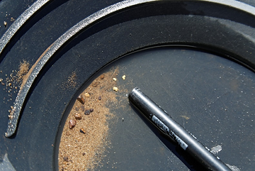
Portable XRF of any description can be a useful tool for geochemical reconnaissance and screening programs. It can train the samplers in real time and helps focus geological mapping,by either direct or indirect mineralisation signatures and lithological information that may discriminate rock types.
Downloading these results with location information into a program like IoGAS, allows rapid assessment of the data quality or usefulness, bearing in mind this is mainly a relative or indicative tool in the field, rather than precise.
Sample above is soil sieved to -1 mm to remove much of the larger rock particles which achieved more consistent results with better numbers and more interpretable data.
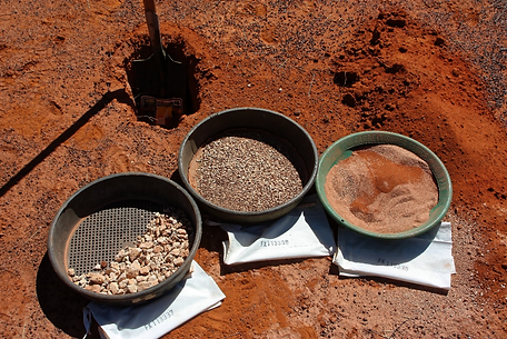
All samples methods (soil, rock, XRF etc) require thought on how, what to sample and consistency in sampling. Poor technique, material and collection usually means poor results and wasted time.
Good quality topography on Google Earth was available at this location. A sign of the things to come.
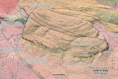
This image illustrates the 3D nature of geological mapping where detailed sampling showed gold was confined between 2 unconformities. Undulations on the basal unconformity are consistent with the current surface erosion resistant ridges. Previous diamond drilling assumed a direct east dip to some better surface sampling. The combination of the north westerly dip of the resistive ridges, and the unconformity surface dip (30 degrees E), mean the geometry of the channels on the unconformity will trend significantly to the NE (green arrows) rather than to the east.
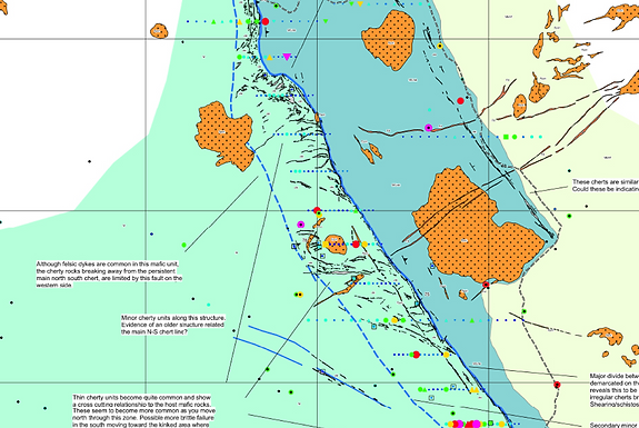
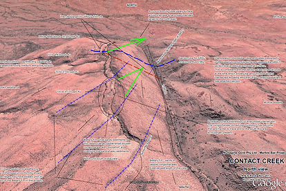
Known regional geology had shown this area to have the same lithology either side of the main structure travelling through the map. Analysis of stream and soil sample results revealed significant litho-geochemical differences that were supported by mapping observations in the field (green and blue-green units). Additional features on this map are the cherty tectonic veins along the structure, sedimentary cover to the east and a series of felsic intrusions. Grid is 1 kilometre.
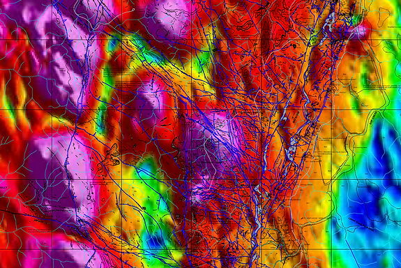
Detailed mapping of complex veining, faults and geology overlain on good quality magnetic data. Grid pattern is 500m.
And as always, the pan can be pretty handy ……….
Drilling
Anything from a shovel or an auger hole……
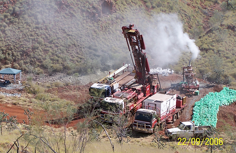
500m + RC drilling in the Pilbara.

Under cover exploration in the Fraser Range Mobile zone.

Useful method to display RC chip for more detailed logging.
Diamond drilling for basin stratigraphy.
Still room for plenty of scissor and pencil work in the planning stage.
Epithermal vein systems.
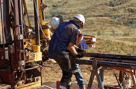
Having room to lay out the core is always good for the down hole mapping phase. It allows for better cross referencing which is useful on new ground, particularly with good surface geology and detailed topography.
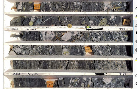
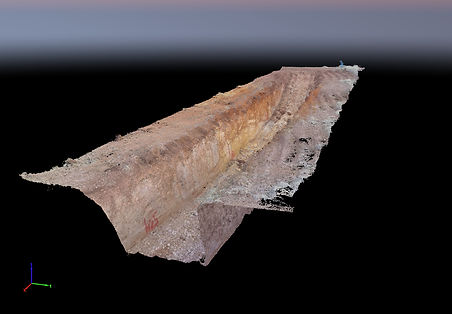
Core trays are photographed, individually ortho corrected and then complied into a continuous tray run. The known tray width gives a scale and with drilling marks, features can be reconsidered, remeasured or even relogged if required.
Being able to compare scaled tray sets is good for multiple holes over different programs. Above is a snapshot of part of a continuous tray image and this was used with a series of diamond holes to assist in cross hole comparisons post normal logging.
Aerial Reconnaissance

The aircraft, a Just Aircraft Superstol, is an ideal platform for oblique and vertical aerial photography, and whilst it can conduct surveys at lower levels for high resolution, it is not restricted to drone ceilings, operating in-sight or some of the weight limitations. Additionally, access to an area can be rapid and survey coverage can be up to some hundreds of sq kms depending on requirements.
Designed specifically as a short take-off and landing aircraft, the handling at low speeds is predictable and stable and with a large speed range (30-90+ knots). Photography and observational flying can be conducted at speeds around 50 knots and still retain high margins on safety and handling.

Flight planning software is able to provide accurate heights and trigger points for different camera and lens combinations to achieve the desired resolution, for instance cm to metre scale. The survey plan is loaded into camera triggering equipment and the actual point of camera firing is collected along with quality control information.
Ground control data can be added at any time from pre flying to post processing.

Plan it, fly it.
An example of imagery used for ortho-photo mosaics and construction of elevation models.


In one sense, particularly if you have the equipment (aircraft and cameras) available, the collection of this imagery is the least of it. The power and usefulness comes from the post processing and then the ability to integrate into a variety of applications and mission requirements.
Pix4d is a premium processing package which then produces the ortho imagery and topography (direct from the photography), which is essential for full utilisation of many types of data and planning requirements.
With accurate and detailed topographic information tied to the imagery, then loaded into GIS of your choice, where the detailed geological mapping can begin its journey into the 3 D environment or you could choose to model the ideal dam site and its irrigation potential.
WHAT I DO
Mapping Style


Available imagery is enhanced and loaded into GIS to prepare for field work applications.
Using geo-location and annotation programs, field data is collected via portable devices.
This method will accommodate large variations in mapping scale allowing suitable detail to be added locally into more regional maps.
Add high mobility and things get done!

Another relatively new tool is the ability to use large amounts georeferenced imagery integrated into GIS (Mapinfo) for direct referencing. With this method thousands of images can be handled and utilized as location in itself provides immediate filtering during actual use. Additional notes can be added to the interrogatable photographic data base as required.
An example of a geological map, illustrating the power of GIS in a larger basin scale mapping programme that has incorporated marker horizons from multi-kilometre to drill scale.
This surface and drilling data was applied into the 3D environment.
Using the same orientation as the map above, viewing at approximately 45 degrees, the marker horizons are added to a good topographic model of the area.
Historical drill data and geological logging has been re-interpreted and combined with current drilling to expand the 3D envelope.
Multiple 3D sections constructed from mapping and drill information.
Here it demonstrated that the Beatons Creek Conglomerate is not a local surface unit and that it has a place within the basin stratigraphy.
This presents a more favourable view of the exploration potential of the area, which under the first phases of drilling, has already outlined approximately half a million ounces of gold in unclosed resources to date.
Geochemistry, geochemical sampling and geology
Geochemistry usually involves a collection of data sets from different batches within the same program to much older historical material.
Any of these may contain known and or unexpected variations. Software like ioGAS allows rapid assessment and the ability to make better use of that data and to explore previously less obvious leads.
This is an example of a single data set and by using ioGAS to handle statistical and location data together, the differences are better understood and can be utilised to advantage.
If appropriate, levelling techniques are used to adjust the data set, as the direct comparison of different result groups may not be appropriate or will even be misleading.
Careful critique of samples collected in relation to geochemical dispersion and secondary weathering effects, will tighten the geological model and expand its regional application.
An eye for geological detail found gold in a new horizon in Archean sediments.

And as always, the pan can be pretty handy ……….
Portable XRF used for geochemical reconnaissance will provide immediate results to help focus geological mapping and sampling via direct or indirect mineralisation and lithological signatures.
All sampling methods (soil, rock, XRF etc) require thought on how, what to sample and consistency in its collection to achieve optimal data.
Mapping and sampling data applied to Google Earth where good quality topography was available.
This image illustrates the 3D nature of geological mapping.
Detailed sampling showed gold was confined between 2 unconformities. Undulations on the older basal unconformity are similar to the present day surface erosion resistant ridges in the left half of the image.
The combination of the north-westerly dip of these resistive ridges and the unconformity surface dip (30 degrees E) show that the geometry of the channels on the unconformity will trend significantly to the NE (green arrows) rather than to the east.
Known regional geology shows this area to have the same lithology either side of the main structure travelling through the map.
Analysis of stream and soil sample results revealed significant litho-geochemical differences that were supported by mapping observations in the field (green and blue-green units).
Additional features on this map are the cherty tectonic veins along the structure, sedimentary cover to the east and a series of felsic intrusions. Grid is 1 kilometre.
Detailed mapping of complex veining, faults and geology overlain on good quality magnetic data. Grid pattern is 500m.
The digital surface model (all objects) above was created exclusively from aircraft aerial images. Other sources include drone imagery and LIDAR for various topographic models.
Rapidly developing software and hardware allows utilization of large amounts of data, and as a result, large topographic surface models for instance, are beginning to be used effectively on individual devices in the field.
This allows for flexibility “on the fly” of combinations of data and methods of looking at it that are required to meet the demands of new information as it is discovered, whether in the field or the office.

Scale through the middle of the image left to right is approx. 10km.

This example above shows the same digital surface model applied to regional radiometeric data.
To appreciate the scale, the obvious model is part of >1000 sq km (at 1 m spatial resolution) data set with a broader K radiometric image.
In this case the application of a very detailed surface model reveals textures that show elements such as jointing and structure, outcrop differences and alluvial terrains with massive zoomable scalability whilst providing strong visual control in the sense of location including hills/valleys etc.
Drilling
Anything from a shovel or an auger hole……
Under cover exploration in the Fraser Range Mobile zone.
Diamond drilling for basin stratigraphy.
Under cover exploration in the Fraser Range Mobile zone.
500m + RC drilling in the Pilbara.
Useful method to display RC chip for more detailed logging.
Diamond drilling for basin stratigraphy

Down hole mapping benefits from well laid out and orientated core.
Core trays are photographed, ortho corrected and then complied into a scaled continuous tray image.
Plenty of scissor and pencil work in the planning stage.
Scaled core tray photograph sets allow subsequent revision, better cross hole comparisons and an easier visual assessment of analytical results.
Aerial Reconnaissance
Photography can be acquired by aircraft, drones and even on the surface. Results are customisable for a variety of applications and industries.

Contoured DSM

Pit geology in 3d
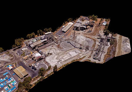
Plant site in 3d
Mapping costeans
Pix4d is a premium processing package which produces the ortho imagery and high quality topography. This provides a base essential for collection and full utilisation of many types of data whether that be geological, agricultural, environmental or fire management.
Accurate topographic information tied to the imagery is required to begin any work into 3D environments.
PROJECTS
White Cliff Minerals, 2022 – current, Gascoyne, Western Australia.
Enhancement of high-resolution satellite imagery with new detailed aeromagnetic and radiometric data. Preliminary interpretation of all types of imagery for field guidance/mapping. Compilation of existing and new geochemical data, planning of mapping and sampling strategies for prospective minerals including REE.
Riversgold Limited, 2023, Pilbara, Western Australia
Data compilation including geochemical, Hyvista, satellite (visual), sentinel2, magnetic and radiometric data sets. Exploration perspective of overall tenure, base map compilation. Principally lithium and gold.
Peregrine Gold Limited, 2022 – current, Pilbara, Western Australia.
Geochemical data compilation onto both high resolution aerial imagery and aeromagnetic/radiometric data sets for detailed mapping bases, detailed geological mapping. Rockchip sampling and reconnaissance mapping.
SIPA Resources Limited, 2022, Pilbara and Kimberley regions, Western Australia.
Geochemical data compilation, satellite imagery and aeromagnetic/radiometric data set compilation for mapping bases, diamond drilling, core mapping/logging, high resolution core imagery and pXRF. Base metal projects in the Wolfe and Canning Basins, Gold in the Pilbara.
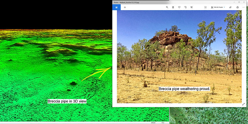
Redbank Copper Limited, 2019 – 2022, Southern McArthur Basin, Northern Territory.
Regional to local mapping, diamond core mapping/relogging and recompilation of new and historical, data set compilation and validation, multi data set integration, recompilation/recoding large and historical drilling data sets, helicopter sampling. Base metal (dominantly copper) exploration.
Helix Resources Limited, 2020, Cobar – Nyngan Region, New South Wales.
Regional and local mapping, multidata set utilisation, Base metal and gold exploration. Station to broad acre agricultural land use.
Golden Lode Pty Ltd, 2019, Goldfields, Western Australia.
Data compilation, surface and drilling data sets, exploration planning.
McKnight, 2018 - current, Eastern Goldfields, Western Australia.
Mapping and sampling, data set compilation and geological interpretation. Drill chip logging, drill data compilation. Dominantly gold systems.
Karri Hill GIS Pty Ltd, 2000 – 2018, Southern Western Australia.
GIS management for project concept work, planning and modelling dam sites for construction requirements, large irrigation design/plantings and optimization.
Novo Resources Corp, 2011 – 2018, Pilbara, Western Australia.
Mapping and sampling including diamond and RC drilling. Data set compilation, extensive drill hole compilation and geological interpretation. Aerial image acquisition and processing, aircraft and drone. Gold in Witwatersrand type scenarios.
Grants Hill Gold Pty Ltd, 2017 - 2018, Pilbara, Western Australia.
Regional to local mapping and sampling Pilbara wide. Area evaluation and prospectivity for principally Witwatersrand style gold deposits. Emphasis on stratigraphy, variance to known geology and geochemical methods and basin configurations.
Nullagine Gold Pty Ltd, Beaton’s Creek Gold Pty Ltd, 2011 - 2018, Pilbara, Western Australia.
Wide regional reconnaissance to intense local exploration/mapping and sampling. Gold in Witwatersrand type scenarios. Mosquito Creek Formation gold mineralisation.
Marindi Metals Pty Ltd, 2015, Newman Zinc Project, 2018, Bellary Project, Pilbara, Western Australia.
Regional to detailed mapping, aerial imagery acquisition.
M. G. Creasy, 1994 – 2013, Pilbara, Western Australia.
Wide regional reconnaissance to intense local exploration/mapping including diamond and deep RC drilling. Broad spectrum geochemistry, variety of mineralisation styles/commodities, complex geology, intrusive and bimodal volcanism. Fortescue and older Archaean rocks.
Meteoroic Resources, 2010, Coorara, NE Southern Cross, Central Yilgarn, Western Australia.
Detailed and reconnaissance mapping, BIF.
Creasy Group of Companies, 2003 - 2012, Pilbara, Goldfields, Fraser Mobile Zone Western Australia.
Regional to detailed geological mapping, broad spectrum geochemistry, variety of mineralisation styles/commodities, data review, geochemical sampling, data retrieval and field validation.
Silver Swan Group Ltd, 2008, Meekatharra District, Western Australia.
Detailed geological mapping.
Geochemex Australia, 1995 – 1998, East Pilbara, (M. G. Creasy), Western Australia.
Thunderlarra Project, Yalgoo, Western Australia.
Gechemical sampling, geological mapping and follow up.
Blue Spec Mining, 1997 East Pilbara (Mosquito Creek Group), Western Australia.
Geochemical sampling.
Giralia Resources, 1996– 1997, East Pilbara (McFee Dome Felsic volcanics - Quartz Circle), Western Australia.
Geological mapping, geochemical sampling, moderately deep (200m) RC exploratory drilling.
Bremer Resources N. L., 1996, Koorong Project – Laverton District, Western Australia.
Geological mapping, project evaluation.
Jubilee Gold Mines N.L. 1992 – 1995, Yundamindra, Kathleen Valley, Malcolm and Benalla Projects (Gold Fields), Western Australia.
Detailed regional geological mapping, geochemical sampling, diamond and extensive RC drilling.
Mining & Development Botswana, St Francis Mining N.L. 1994, Francistown, Botswana, Africa.
Commencement of geological exploration, prioritise work requirements, rank longer term strategies, amend tenure to support exploration trends, establish exploration guidelines, supervise personnel and drilling, regional and detailed data assessment.
Sundowner Minerals N.L., 1990 - 1992, Darlot, (Northern Gold Fields), Western Australia.
Geological mapping, diamond & RAB drilling, geochemical sampling.
Delta Gold N. L., 1991, Shamva Project, Zimbabwe, Africa.
Project Geologist, geological mapping, data retrieval and validation, geochemical sampling, costeaning and auger sampling, felsic volcanic terrane, strong liaison with land occupiers/farmers.
Battle Mountain Australia Inc, 1990, Plutonic Bore Leases, Meekatharra, Western Australia.
Detailed regional mapping.
Northern Gold N. L., 1988 – 1990, Adelaide River, Pine Creek Geosyncline, Northern Territory. Parry Range, West Pilbara, Western Australia.
Project management, geological mapping, geochemical sampling, extensive RC drilling, bringing back tenement reporting and management to order, involved in Supreme Court action.
Geological mapping and geochemical sampling.
Forsayth Mining Servics, 1986 – 1988, Lawlers Project, Northern Gold fields, Western Australia.
Principally pre-production exploration to production status, extensive drilling, regional and detailed geological mapping, exploration geochemical sampling.
Mackay and Schnellman Pty Ltd, 1985 – 1986.
Wide variety of projects. Work included detailed geological mapping, preparation work and site visits for prospectus and valuation requirements, aerial photograph interpretation, drilling and costeaning, ground magnetic surveys.
M. J. Longman & Associates, 1980 – 1985.
Involved in numerous projects and commodities for a diversity of clients in Australia and overseas. Landsat imagery and aerial photography interpretation for petroleum, base metal, gold and other commodities. Reconnaissance to detailed geological mapping, drill planning and supervision using a variety of methods, geochemical, magnetometer and gravity surveys, pegging and property acquisition, literature searches.
PHOTO GALLERY
CONTACT
Inquiries
For any inquiries, questions please email me using the form below.